- K-State home
- Rec Services home
- Fitness
- Challenge Course
- Location and directions
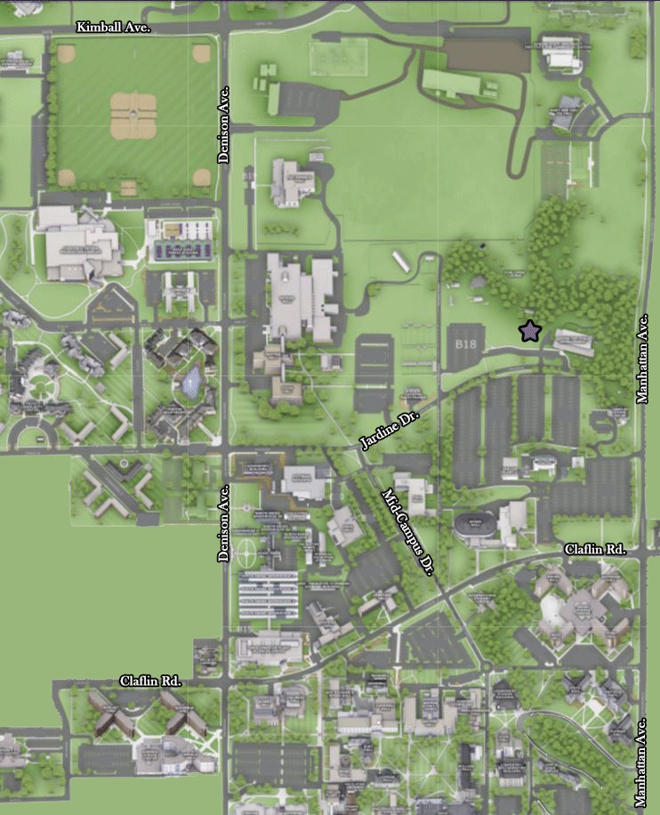
Location and Directions to K-State Challenge Course

Located next to K-State Child Development Center
Getting Here by Car
GPS coordinates: N 39 degrees 11.55 W 096 degrees 34.47
- Take I-70 West.
- Turn right at exit 313 (K-177 North) and drive approximately 9 miles.
- After you go over the Kansas River bridge, take the Fort Riley Boulevard exit.
- You will see the Town Center Mall in front of you.
- Turn left at the stoplight onto Tuttle Creek Boulevard.
- Turn left at the Bluemont Avenue stoplight.
- Travel 10 blocks to the Manhattan Avenue stoplight. You will see the campus in front of you.
- Turn right at the stop light onto Manhattan Avenue.
- Travel 7 blocks north to the Claflin Road stoplight.
- Turn left onto Claflin Road. You will be entering campus.
- Turn right onto Mid-Campus Drive at the four-way stop.
- Turn right onto Jardine Drive.
- Turn left on Serum Plant Rd at the Z B18 parking lot sign.
- Turn right into the Z B18 parking lot. (quick right)
- The Challenge Course is straight up the small hill past the open grassy area.
- Take I-70 East.
- Take exit 303 (K-18 North) and turn left onto K-18.
- Drive about 10 minutes on K-18 (it changes into Ft. Riley Boulevard on the edge of Manhattan).
- Turn left at the 17th Street stoplight. Travel 11 blocks to the Anderson Avenue stoplight. You will see the campus in front of you.
- Turn left onto Anderson Avenue at the stoplight.
- Turn right onto Denison Avenue at the stoplight and travel north along side of the campus to the Jardine Drive/Mid Campus Drive stoplight.
- Turn right onto Jardine Drive/Mid Campus Drive.
- Turn left at the Z B18 parking lot sign onto Serum Plant Road.
- Turn right into the Z B18 parking lot. (quick right)
- The Challenge Course is straight up the small hill past the open grassy area.
- Take Highway 13 South to Highway 113.
- Turn left on 113 (which turns into Seth Childs Road) and travel south to Anderson Avenue.
- Turn left on Anderson Avenue and travel east to Denison Avenue
- Turn left onto Denison Avenue at the stoplight.
- Travel north along side of the campus to the Jardine Drive/Mid Campus Drive stoplight.
- Travel 7 blocks north to the Claflin Road stoplight.
- Turn right onto Jardine Drive/Mid Campus Drive.
- Turn left at the Z B18 parking lot sign onto Serum Plant Road.
- Turn right into the Z B18 parking lot. (quick right)
- The Challenge Course is straight up the small hill past the open grassy area.
- Take K-177 North to Manhattan.
- After you go over the Kansas River bridge, take the Fort Riley Boulevard exit.
- You will see the Town Center Mall in front of you.
- Turn left at the stoplight onto Tuttle Creek Boulevard.
- Turn left at the Bluemont Avenue stoplight.
- Travel 10 blocks to the Manhattan Avenue stoplight. You will see the campus in front of you.
- Turn right at the stop light onto Manhattan Avenue.
- Travel 7 blocks north to the Claflin Road stoplight.
- Turn left onto Claflin Road. You will be entering campus.
- Turn right onto Mid-Campus Drive at the four-way stop.
- Turn right onto Jardine Drive.
- Turn left on Serum Plant Rd at the Z B18 parking lot sign.
- Turn right into the Z B18 parking lot. (quick right)
- The Challenge Course is straight up the small hill past the open grassy area.